Drillholes
This
Streamlined Create DHDB / Trench Database
The Create Drillhole Database and Create Trench Database forms have been redesigned to enable all DAT files to be selected at once. Collar, survey, interval and event files will be detected and the key fields will automatically populate the form ready for review
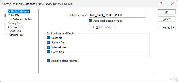
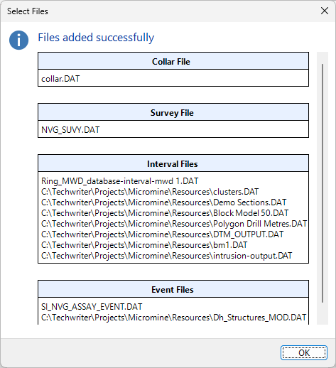
Using the Select Files button, you can select a database, and multiple collar, survey, interval and/or event files to add to the form. Information for the files added successfully will be autofilled on the relevant tabs. You will be notified that the files have been added, and a prompt will display the type and name of each file (Collar, Survey, Interval, Event) in the database.
Auto Load Trace
The Auto load trace option has been added to the Create Drillhole Database and Drillhole Database forms to automatically load the drillhole trace layer in Vizex.
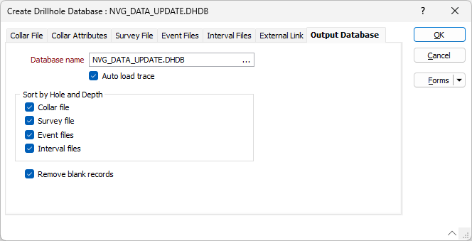
By default, this option is ON for the Create Drillhole Database form and OFF for the Drillhole Database form when editing. The autoloaded trace layer will load using the default Drillhole Trace layer settings with the Show Collar option set to ON.
Note: If this option is ON and you have chosen to open the DHDB Viewer to fix any existing errors, the Viewer will be opened in the background and the automatically loaded drillhole trace in Vizex will be given focus.
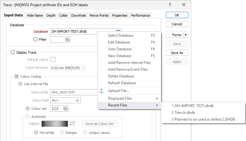
Recently Used Drillhole Databases
Recently used drillhole databases will now be tracked and the last used drillhole database will automatically be populated in forms that are used for the first time.
Forms that have already been used will contain the last used drillhole database by default, and you can view a list of Recently used database files using the right-click menu - as with other files throughout Micromine Origin & Beyond:
Distance to Drillhole
The Distance to Drillhole tool has been added on the Drillhole tab, in the Calculations group to enable you to model the spacing and distances between drillholes in a database.
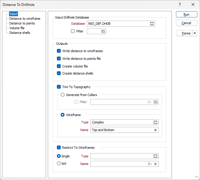
For mineral exploration and the planning of drillhole locations, it is useful to assess the distance between a location existing drillholes. This can often be achieved using either a block model, by colouring a wireframe by a distance attribute, or by creating buffer wireframes around drillholes.
The Distance to Drillhole tool provides a simpler solution by allowing users to select an input drillhole database and select from several different output options to assess the distance to drillholes.
For information on using the new tool, see Distance to Drillhole.
Extend Drillhole From Collar
The Extend to DTM and Extend Beyond Target options have been added to the Drillhole Planning | Drillhole From Collar tool on the the Drillhole | Planning tab, in the Planning group .
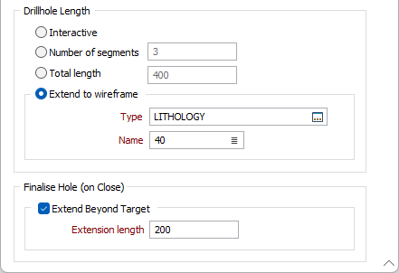
If you select Extend to DTM and specify the Type and Name of a DTM to snap to, the point at which the DTM is pierced by the trace string will determine the length of the hole.
The Extend Beyond Target option will lengthen the hole by the specified Extension length.
Open Plan
The Open Plan and Load Drillholes Into Plan options have been added to the Drillhole Planning tool on the the Drillhole tab, in the Planning group .
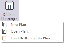
The Open Plan option opens an existing drillhole plan. By Default, the Drillhole Planning button creates a new Drillhole Plan. The Open Plan button provides the option to load and configure an existing file in the Planning form to open it as a Drillhole Plan layer in Vizex in Planning Mode.
The Load Drillholes Into Plan option will open the form to import drillholes from a specified Drillhole Database or Trace String file and start a new Drillhole layer editing session.
Solid Trace Minimum Grade
The Minimum option has been added to Solid Trace display to allow plotting of grades below 1 on a log scale.
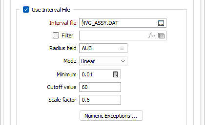
Ordinarily, when using downhole solid traces to display data on a log scale, any grade value below 1 receives a negative radius and therefore will be assigned the default radius. This can mean it is unclear whether assay values are low or if the interval was unassayed. The radius of some intervals with lower grades can be greater than the radius of intervals with higher grades, depending on the default radius. Grade values below 1 are very important for commodities such as gold.
The Auto calculate button will calculate the Minimum grade value based on the information in the input file.
Add Coordinate Fields
The Drillhole Coordinate Calculator has been updated to automatically create fields if not previously present, and overwrite already existing fields.
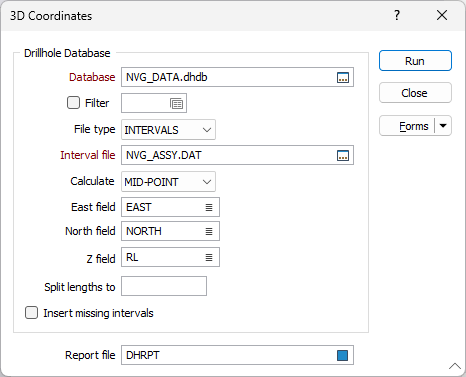
If the required fields are blank/ Auto, the Easting, Northing and RL values from the collar file will be utilised.